Theme Layout

Boxed or Wide or Framed

Theme Translation

Display Featured Slider

Featured Slider Styles

Display Grid Slider

Grid Slider Styles

Display Trending Posts

Display Author Bio

Display Instagram Footer

No

Dark or Light Style

Dark

lake seloton, lake sebu


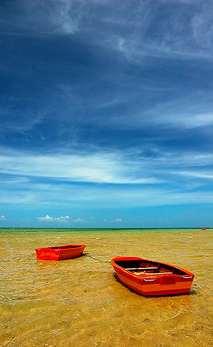
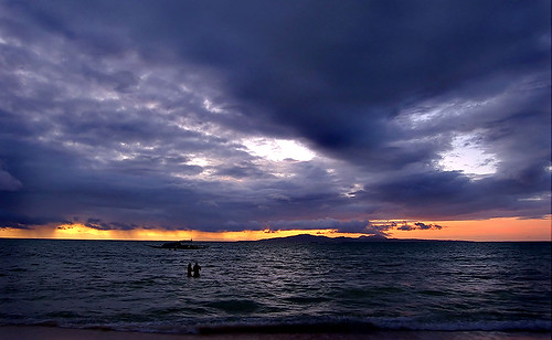
Moody weather in Lake Seloton

Some (especially those not familiar with Southern Mindanao) are confused when you say Lake Seloton is in Lake Sebu (a lake in a lake?!?). Lake Sebu happens to be the name of both the town and the largest lake of the three lakes there. The other two lakes are Lake Seloton and Lake Lahit.

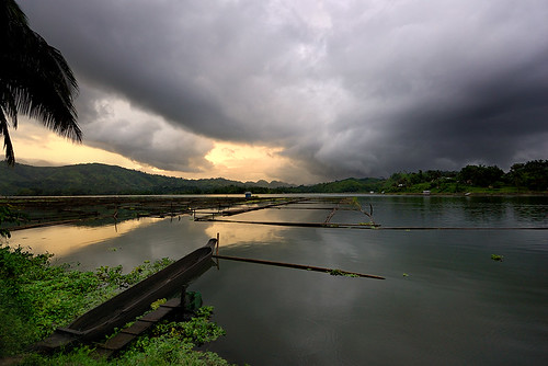
Lake Seloton, a few minutes away from the town proper, is Lake Sebu's most beautiful little sister. Its smaller in size (but reputed to be the deepest of the three lakes) but is just as magnificent as the larger lake. What makes Lake Seloton more special is that it has the best unblocked view of sunrise, hence visitors often refer to it as the "Sunrise Lake". You will not be disappointed with the sunset there too.

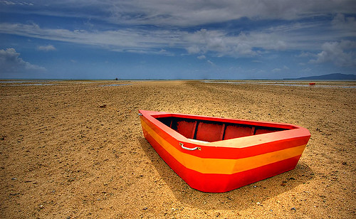
I planned to take sunrise photos there, but if you are vacationing with the family, photography sometimes takes a backseat. So I had to compromise - take photos of Lake Seloton at dusk, with menacing storm clouds threatening to ruin whatever sunset colors I may capture. Well you have to take what is given :).

I was able to take a just a few shots (less than 10 shots actually) before rain fell, heavily. But I was not disappointed. Rain brings a different sense of peace. I can stare at the raindrops for a very long time.

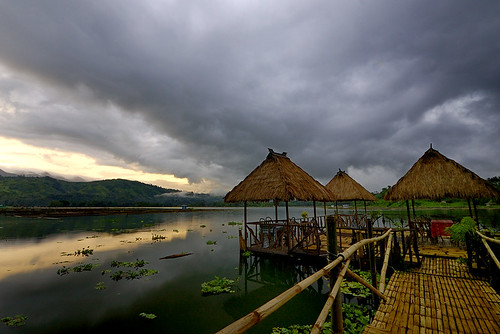
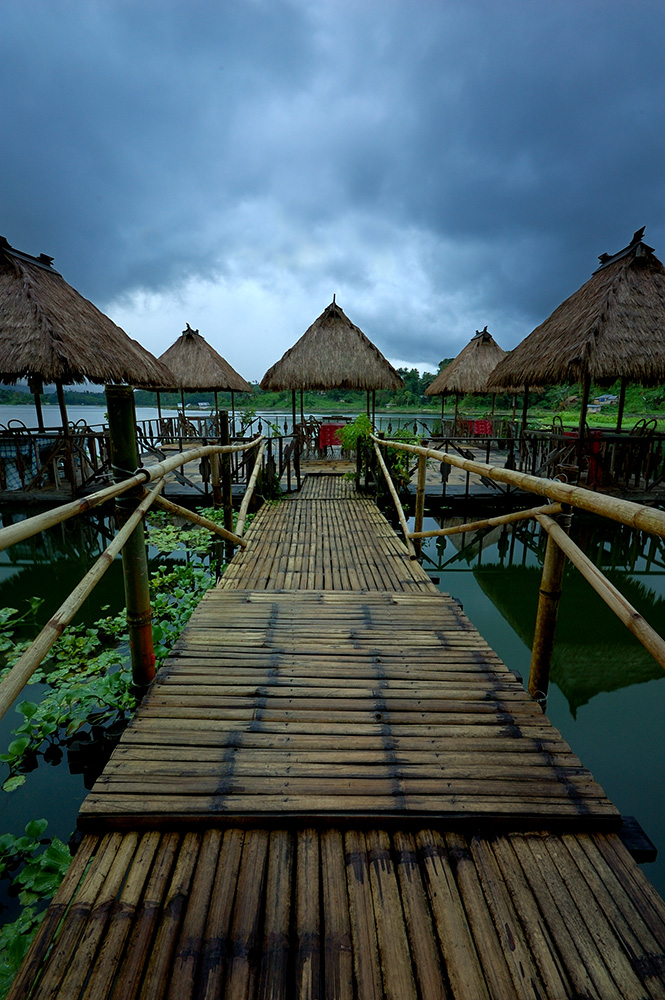
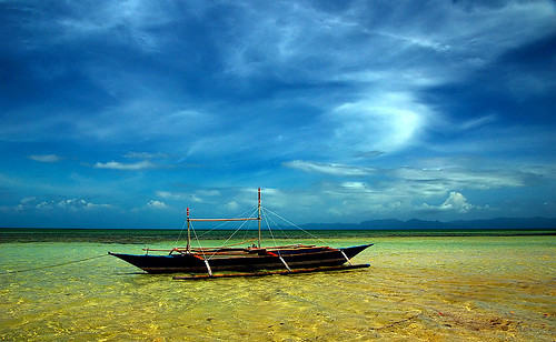
A nice bed weather in Lake Seloton

My good friends Ferdz Decena and Oggie Ramos (both are travel/outdoor photographers extraordinaire for various magazines, Ferdz recently guested in a TV show and Oggie's photo is the cover of SeaAir's Aug-Sept 2008 inflight magazine) had much better luck getting sunny photos of Lake Seloton during their last visit there. You may read Ferdz's writeup about Lake Seloton here.

There is a resort called Sunrise Resort (go figure hehe) in Lake Seloton if you want to wake up to a beautiful lake side sunrise if you happen to be in Lake Sebu.
QuickEdit
Lantaw
2 Comments
Share This Post :

dongon falls, lake sebu


One of the many attractions in the sleepy lakeside town of Lake Sebu in South Cotabato is the series of 7 majestic falls collectively called the "Dongon 7 Waterfalls" or simply "Seven Falls" (there is some confusion as to which of the falls is really called the "Dongon Falls"). The falls and its related river system passes through the hectares of land under the care of the Dongon family (pronounced as "don-gon" and not as "do-ngon").

2nd Falls as seen from afar

I hiked here with my dad decades ago. There was no dirt road back then and we had to slash our way through dense undergrowth. I remembered passing through a bamboo forest with really huge bamboo trees. Nowadays there is a passable road (still rough but passable) going down to the 2nd falls. Its downhill all the way to the falls, with a deep ravine to your left and a mountain wall to your right.

Now its my turn to bring my kids there, on board a habal-habal (motorcycle). Since its monsoon, rainfall is much more frequent (considering the area is already in a rain forest!). The road is very slippery with mud and the rocks/stones are loose (we had to walk some sections of the road). It made the ride more thrilling - the thrill you get with roller coasters. My wife was pretty scared but the kids absolutely loved it :).

Jaila and Jacen
Jaila and Jacen love the outdoors too!

The area near the falls is covered with mist from the spray of the falls. It was a challenge getting near and getting a decent shot. Most of the time my filter is covered with droplets. Lighting is also very tricky - sunny for few seconds then suddenly overcast and drizzling without notice.

White Water Rush
Raging waters, mud colored during the monsoon.

The falls is much tamer during the summer and the water much clearer. The provincial government has developed the surrounding areas of the 2nd falls. There are established walkways and as I was hiking up (to ease the load on the motorcycle hehe) I passed by a winding stairway being constructed near the top of the falls.

Of the 7 waterfalls, the 1st and the 2nd are the most accessible. The first being just a few minutes hike from the fork near the 2nd falls.

Name Game

So which one exactly, of the seven falls, is called the Dongon Falls? Well the series of falls is actually referred to as the "Dongon 7 Falls". There used to be huge sign board at the start of the trail, bearing that name, that shows directions to the 2nd falls for hikers.

Of the two accessible falls, Falls #1 is in much closer proximity to the Dongons' house. There was no man made structures in Falls #2 before. Naturally hikers (and bloggers) came to refer to Falls #1 as the Dongon Falls and simply call the other Falls #2, Falls #3, etc.

Bridge to 2nd Falls

Nowadays, its the Falls #2 which is being "aggresively developed" by the provincial government. Its the tallest and most majestic of the 7. The area around 2nd falls is much more "roomy" - which means they can put up cottages and I heard they even plan to build a swimming pool nearby. A real eco-disaster in the making.

The 2nd falls has now become the "face" of the Dongon Falls as seen from travel brochures and huge ad boards.

More photos here

Nowadays the each of the 7 falls have official and politically correct T'boli names (see this post: http://lantaw.blogspot.com/2009/04/lake-sebu-falls-2-up-close.html
QuickEdit
Lantaw
17 Comments
Share This Post :

lake sebu, south cotabato


Lake Sebu at dusk with lingering storm clouds

Lake Sebu is a rustic town nestled about 1000 metes above sea on the mountains of the Allah Valley region in South Cotabato. It bears the same name as the largest of the three lakes found there (Lake Sebu, Lake Seloton, and Lake Lahit). It is a favorite summer destination because of its cool climate and its idyllic setting.

My kids were particularly excited when I told them we are going to spend the weekend at Lake Sebu and see one of the major falls there (Thank God they love the outdoors too ... second to PSPs and Gameboys). I was pretty perked up too. As a young lad, I spent a good number of summer vacation days there with my dad but have not been able to spend more than a day there lately (work and other things got in the way). This will be the first time I'm going to experience Lake Sebu in the monsoon.

The area around Lake Sebu is the ancestral domain of the T'bolis - one of the indigenous people of Southern Mindanao. The T'bolis are known for their brass works and their tinalak - a cloth with beautiful geometric patterns woven from abaca fiber (Manila hemp). They are basically farmers and fisher folks (main industry of the town is tilapia farming).

Finding a place to stay in Lake Sebu is not hard especially in the off peak season. There are lake side resorts with modest huts and comfortable rooms to choose from.

Floating huts at dusk

I was expecting a moody weather and was not disappointed. Minutes after we arrived there, Mother Nature greeted us with a heavy downpour. As dusk falls, a soothing serenity settled on the place. The nearby mountains seemed to retreat farther as the fog creeps in to cover them for the night.

Twilight huts

Along with the silence of twilight comes the soft (and very cool) evening breeze. I spent a few minutes savoring nature's daily gift of sunset colors on this floating platform before heading off to dinner (charcoal grilled tilapia - straight from the lake to the grill). Its a far cry from the hot and humid place we came from just a few hours ago.

How to get there
There are daily flights from Cebu/Manila to General Santos City

1. From General Santos take a bus to Koronadal City (65 km, 80 pesos). There are aircon and non aircon buses.
2. From Koronadal take a bus (on the same bus terminal) to Surallah (30+ km, 25 pesos).
3. From Surallah take a van to Lake Sebu (30+ km, 30 pesos).

Common transportation within the town are motorcycles (called habal habal by the locals) that can accommodate 4-5 persons. The riding experience is at par with that of a roller coaster ride if you are careening down a bumpy rough road on board one.
QuickEdit
Lantaw
5 Comments
Share This Post :

finding licao-licao


Our MTB trip last weekend took us through the provinces of Rizal and Bulacan. No GPS, no maps. Just pure MTB fun in discovering back roads and mountain trails.

(before the downhill to San Jose L-R Elias, George, me, Owen)

Here's a run down of our trip:

1. Caloocan to Litex (via Nova Bayan, Commonwealth Ave) - paved road, rolling hills
2. Litex to crossing San Jose - Montalban (paved, treacherous downhill)
3. San Jose to Macabod (paved steep uphill, then rough rolling hills)
4. Macabod to Licao-Licao (rough rolling hills)
5. side trip Licao-Licao to falls in Mt. Balagbag (punishing rough uphill portion then rolling hills)
6. Licao - Licao to Tungko (very rough road and then there is about 5km very treacherous downhill in Pangarap)
7. Tungko to Nova (paved road)

Total distance for the trip is 72.89 km.

We found a small brick village smack in the middle of an acacia forest somewhere midway between Licao-Licao and Tungko. Its a small community (with a brick courtyard and brick houses) detached from civilization. It was like being transported into another time and place. Unfortunately our camera was out of juice.

Here's some photos we took along the way:

Pit stop for some fresh buko (at 10 pesos only!) and some santol

ready for the next leg

Enjoying the downhill. I was going down nice and fast on this downhill section only to encounter a huge truck in the opposite direction (going down the opposite hill) hogging the small road. So much for using the downward momentum to attack the next uphill :).

weeeeee!


We cooled down at Balagbag falls (Mt. Balagbag has great killer uphill sections) with some delicious suman (rice cake) we bought in a small store at our pit stop. It was a short walk downhill to the falls and Mother Nature decided to give us a welcome shower 5 minutes after we arrived in the falls. We were too tired and hungry to care. Rain was a welcome respite and our meager lunch was a feast.

(tired and weary and the punishing rough roads are still ahead)


So how punishing were the trails really?

1. Owen blew his rear interior tube. He also has to replace his brake pads. We all have to use our brakes heavily.

2. Raymond (the youngest in our group) went over the handle bar.

3. My left pedal needs to be replaced.

4. Elias' left and right pedals have to be replaced.

5. George cut his left knee. He also has to align both his front and rear wheels. All his rear spokes are loose.

But unlike our two previous MTB trips we didn't have really bloody cuts (last two indicents involved me hehe).
QuickEdit
Lantaw
2 Comments
Share This Post :

riding kaye


I've recently been introduced to mountain biking and I absolutely love it! Been riding "Kaye", my K2 bike (yes I give names to my equipment including my camera gears), every Saturdays and/or Sundays mostly around Montalban in Rizal province.


I'm an outdoor photography enthusiast (I have a photo/travel blog here) and mountain biking fits me to a tee - I get to see places and enjoy nature. However its quite difficult to bring photo equipment during an MTB trip so most of the photos you'll see here are taken with a cheap point and shop camera :).
QuickEdit
Lantaw
0 Comments
Share This Post :

missing cagbalete island


Orange skiffs on a hot summer day

Cagbalete Island in Mauban, Quezon (eastern side of Luzon, Pacific Ocean) is one of my most favorite destination. Ironically I have not written about it until now (a friend wrote extensively about our sojourn there in his blog libot).

Its a gem of an island off the coast of Mauban (4-5 travel hours from Manila, great directions on how to go there from this site - maintained by one of the resort owners. Some of my photos ended up in their gallery) with white sand beaches that can rival those in the popular resorts here in the Philippines.

From Mauban, its a 45 minute boat ride to the island. There are usually two trips daily, one in the morning (around 10AM) and another in the afternoon. Folks from Cagbalete constantly commute to Mauban to get supplies or to conduct trade. Cagbalete produces lambanog - a vodka like liquor fermented from sasa (a palm-like tree that usually grows on marshes and river banks).

Mang Lito (boat captain) personally ferried us to the shore

The island is bordered by Lamon Bay in the west and the Pacific Ocean in the east. It is privately owned but there is a small fishing community, called Sabang, in the southwestern part of the island.

A Cagbalete welcome (Sabang)

During low tide (at around 8AM and another one at around 9PM), a huge expanse of beach in the eastern side of the island is transformed into a desert like landscape. The water recedes almost 800 meters from the shore.

A stranded skiff

Low tide sand ripples

Cagbalete also has a diverse wildlife ecosystem. It is home to a variety of species of birds and land animals. You'll be able to see flocks of birds feeding on crustaceans and small fishes trapped in pools of water during low tide.

For those who can wake up early, Cagbalete's east side offers a great view of Pacific sunrise.

A Pacific sunrise

So whether you are a beach bum or a nature lover, Cagbalete has something to offer you. (I was happy to inspire quite a few to visit Cagbalete)

A Cagbalete summer day

But alas the rainy days are here! The mighty Pacific cooks up a storm on a weekly basis. I guess we all have to long for Cagbalete until the next summer.

More Cagbalete photos here.
QuickEdit
Lantaw
11 Comments
Share This Post :

Follow @lantawphotos